

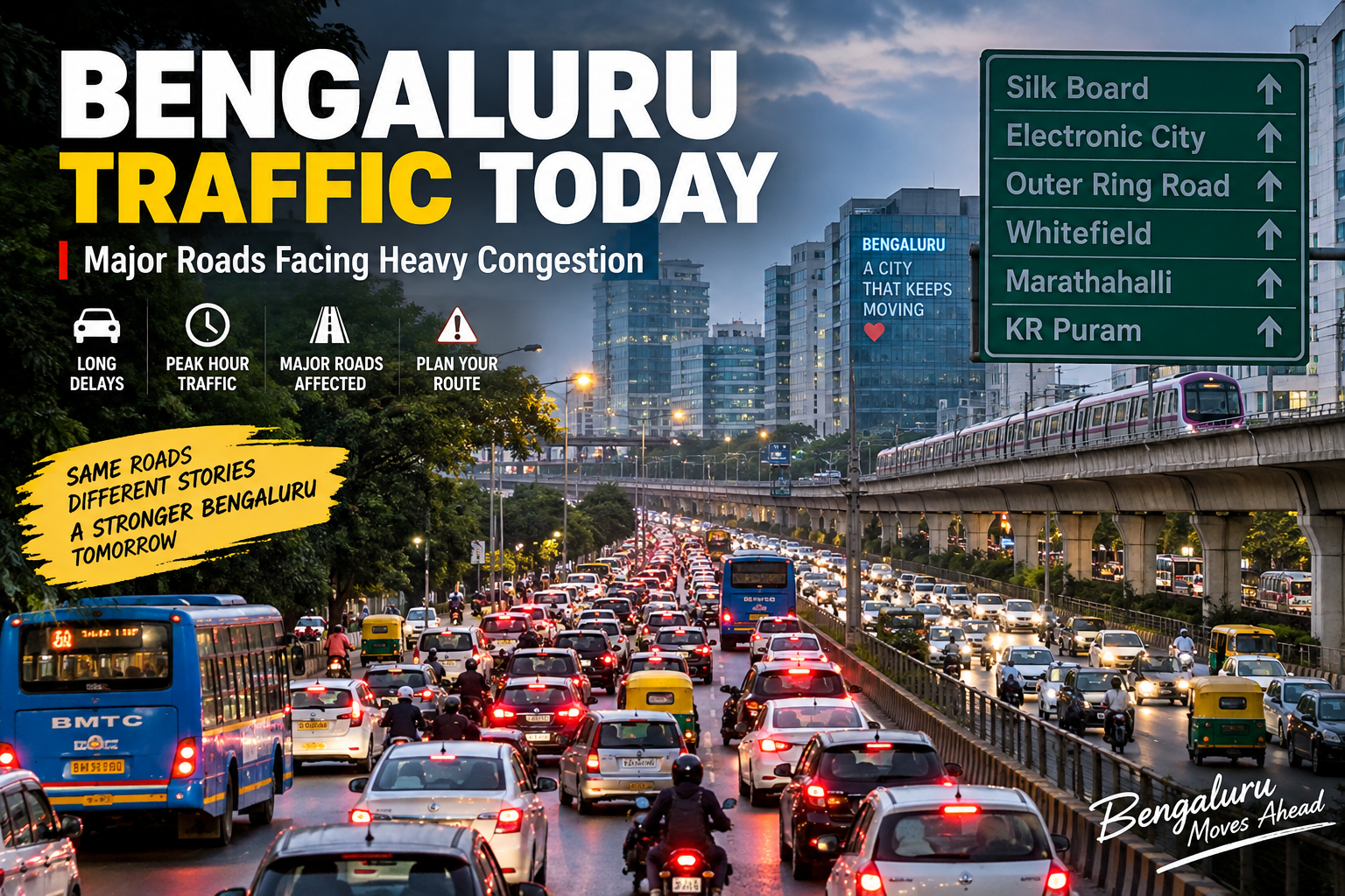
Bengaluru's traffic problem is no longer limited to a few notorious junctions. As the city has expanded into a major technology, business and residential hub, daily commuting has become a challenge for millions of people.
Today, commuters should pay particular attention to major corridors such as the Outer Ring Road (ORR), Silk Board, Hosur Road, Bannerghatta Road, Whitefield, Marathahalli and Bellandur. Recent weather reporting has also warned that rain can slow traffic around major junctions, technology corridors and low-lying roads.
The scale of Bengaluru's congestion is also reflected in international traffic data. TomTom's 2025 Traffic Index recorded an average congestion level of 74.4% for Bengaluru, up 1.7 percentage points from 2024. The average travel time for a 10-km trip was 36 minutes 9 seconds, while rush-hour drivers lost approximately 168 hours during the year.
AI Answer Box: Bengaluru Traffic Today
Bengaluru traffic today is likely to be slower on major IT and arterial corridors, particularly during peak travel periods. Roads and areas commuters should watch include the Outer Ring Road, Silk Board, Hosur Road, Bannerghatta Road, Whitefield, Marathahalli, Bellandur and KR Puram.
Rain can further increase delays because wet roads, reduced visibility, waterlogging and slower vehicle movement can create secondary congestion. Commuters should check the latest Bengaluru Traffic Police and navigation-app updates immediately before starting their journey.
Important: Traffic conditions can change within minutes. A road listed as congested earlier may clear quickly, while an accident, breakdown, roadwork or rainfall can suddenly create a new bottleneck.
Bengaluru Traffic Today: Which Roads Are Most Important to Watch?
1. Outer Ring Road
The Outer Ring Road remains one of Bengaluru's most important traffic corridors because it connects several major employment centres and residential areas.
The ORR corridor includes high-traffic zones around:
- Marathahalli
- Bellandur
- Mahadevapura
- Doddanekkundi
- KR Puram
- Hebbal
The road's importance means that even a relatively small disruption can have a knock-on effect on connecting roads.
Recent community discussions also continue to highlight how the ORR has effectively become an urban employment corridor rather than a peripheral road as Bengaluru has expanded.
2. Silk Board Junction
Silk Board is another long-standing Bengaluru traffic bottleneck.
The junction connects important routes including:
- Hosur Road
- Outer Ring Road
- Electronic City corridor
- BTM Layout
- HSR Layout
- Bommanahalli
A Karnataka government document describes Central Silk Board as handling very high traffic volumes involving cars, two-wheelers, BMTC buses, cabs and goods vehicles. It also identifies peak-hour queues and the interaction of several major roads as key congestion challenges.
Why Silk Board Gets Congested
The problem isn't simply the number of vehicles.
Traffic has to merge and diverge between multiple corridors, while nearby commercial and residential development adds additional local traffic.
3. Whitefield and ITPL Road
Whitefield remains one of Bengaluru's biggest employment and residential areas.
Traffic pressure can increase around:
- ITPL
- Hoodi
- Hope Farm
- Kadugodi
- KR Puram
- Whitefield Main Road
The large concentration of offices, apartment communities, schools and commercial establishments means that traffic is heavily influenced by commuting patterns.
4. Marathahalli and Bellandur
The Marathahalli-Bellandur stretch is particularly important for technology-sector commuters.
Traffic can build up around:
- Marathahalli Bridge
- Kundalahalli
- Bellandur
- Devarabeesanahalli
- Ecospace area
- ORR junctions
The area also connects commuters travelling between Whitefield, Sarjapur Road, Electronic City and northern parts of the city.
5. Electronic City and Hosur Road
Electronic City is another major employment hub.
Hosur Road traffic can affect commuters travelling between:
Electronic City → Bommanahalli → Silk Board → HSR Layout → Central Bengaluru
Recent reporting also shows authorities are reassessing restrictions on two-wheelers on the Electronic City elevated corridor after traffic assessments and concerns about the effects of diversions.
6. Bannerghatta Road
Bannerghatta Road is another important southern Bengaluru corridor.
Traffic pressure can increase around:
- Arekere
- Hulimavu
- Gottigere
- JP Nagar connections
- Dairy Circle
- Bannerghatta Road junctions
Rain can make the situation more difficult because slower traffic and localized waterlogging can reduce road capacity.
7. KR Puram Junction
KR Puram is a critical interchange between several major routes.
It connects traffic from:
- Whitefield
- Old Madras Road
- Outer Ring Road
- Hoodi
- Mahadevapura
- Hoskote side
Because several traffic streams converge here, congestion can quickly spread to surrounding roads.
Bengaluru Traffic Data: How Serious Is the Problem?
TomTom's 2025 Traffic Index provides a useful picture of Bengaluru's broader congestion problem.
| Traffic Indicator | Bengaluru |
|---|---|
| Average congestion | 74.4% |
| Change from 2024 | +1.7 percentage points |
| Average travel time for 10 km | 36 min 9 sec |
| Average rush-hour speed | 13.9 km/h |
| Time lost during rush hour | 168 hours |
| Evening rush-hour congestion | 115.2% |
| Morning rush-hour congestion | 94.2% |
These figures are 2025 annual traffic data, not live measurements for today. TomTom says its calculations are based on anonymised trip data covering the road network in the Bengaluru metropolitan and city areas.
Bengaluru Compared With Other Major Indian Cities
| City | 2025 Congestion |
|---|---|
| Bengaluru | 74.4% |
| Pune | 71.1% |
| Mumbai | 63.2% |
| New Delhi | 60.2% |
| Kolkata | 58.9% |
| Jaipur | 58.7% |
| Chennai | 58.6% |
| Hyderabad | 55.5% |
Bengaluru recorded the highest congestion level among the Indian cities listed in TomTom's 2025 India ranking.
Why Is Bengaluru Traffic So Bad?
Rapid Urban Growth
Bengaluru has experienced extraordinary expansion in both population and employment.
New residential communities have developed around employment centres, while workers frequently travel considerable distances between homes and offices.
Concentration of IT Jobs
Large employment clusters around:
- Whitefield
- ORR
- Bellandur
- Marathahalli
- Electronic City
generate enormous commuter flows.
Limited Road Space
Road expansion cannot always keep pace with vehicle growth and urban development.
Junction Bottlenecks
A wide road can still experience severe congestion if traffic eventually has to pass through a narrow junction.
Road Construction
Metro works, flyovers, utility work and road upgrades can temporarily reduce available road capacity.
Weather
Rain can have a disproportionate impact when it coincides with peak commuting hours.
Recent Bengaluru weather reporting specifically warned that rain could slow traffic on ORR, Hosur Road, Bannerghatta Road and around Silk Board.
What Time Is Bengaluru Traffic Worst?
While conditions vary by location and day, commuters generally experience heavier traffic during:
Morning Peak
Approximately 8 AM–11 AM
Office and school traffic combine to increase pressure on major arterial roads.
Evening Peak
Approximately 5 PM–9 PM
Evening traffic can be particularly difficult because office commuters, commercial traffic and local trips overlap.
TomTom's 2025 data shows Bengaluru's evening rush hour was slower than its morning rush hour, with a reported 45 minutes 27 seconds for a 10-km journey during evening rush hour, compared with 41 minutes 6 seconds in the morning.
How Can Bengaluru Commuters Avoid Heavy Traffic?
Step 1: Check Traffic Before Leaving
Don't rely only on yesterday's traffic pattern.
Check:
- Google Maps
- Waze
- Bengaluru Traffic Police updates
- Local traffic advisories
Step 2: Leave Before the Peak
If your schedule allows, travelling outside the busiest periods can significantly reduce journey time.
Step 3: Consider Metro Connectivity
For suitable routes, Bengaluru Metro can provide an alternative to road travel.
Step 4: Avoid Unnecessary Car Trips
Carpooling, public transport and two-wheeler travel where safe and appropriate can reduce the number of cars occupying road space.
Step 5: Keep Extra Time During Rain
Never calculate a rain-day journey using your normal travel time.
Traffic Problems vs Possible Solutions
| Problem | Possible Solution |
|---|---|
| Too many private vehicles | Better public transport and carpooling |
| Junction bottlenecks | Signal optimisation |
| Poor last-mile connectivity | Feeder buses and better walking infrastructure |
| Road construction | Better project coordination |
| Flooding/waterlogging | Improved drainage |
| Illegal parking | Stronger enforcement |
| Uncoordinated development | Integrated transport planning |
| Peak-hour overload | Flexible work hours and staggered office timings |
Pros and Cons of Different Ways to Travel
| Mode | Advantages | Disadvantages |
|---|---|---|
| Metro | Avoids road congestion | Last-mile connectivity can be an issue |
| BMTC bus | Affordable | Can be delayed by road traffic |
| Two-wheeler | Flexible and easier through slow traffic | Greater exposure to weather and road risks |
| Car | Comfortable for families | Parking and congestion problems |
| Carpool | Shares travel costs | Requires matching schedules |
| Walking | Zero traffic contribution | Practical only for shorter distances |
Expert Commentary: What Bengaluru Needs
Traffic management is not simply about constructing more roads.
A sustainable solution requires integrated transport planning.
That means combining:
- Metro expansion
- Bus priority
- Better pedestrian infrastructure
- Intelligent traffic signals
- Junction redesign
- Parking management
- Drainage improvements
- Transit-oriented development
- Better last-mile connectivity
TomTom's latest global analysis similarly highlights the importance of data-driven transport planning as congestion continues to affect major cities worldwide.
Real-World Commuter Experience
For Bengaluru residents, the biggest frustration is often not the absolute distance but the unpredictability of travel time.
A 10-km journey can feel manageable one day and become dramatically longer after:
- A vehicle breakdown
- Heavy rain
- A minor accident
- Road construction
- A traffic signal failure
- A large event
- School-hour traffic
Recent reporting highlighted a Bengaluru commuter's nearly three-hour Electronic City-to-Whitefield journey, illustrating how quickly everyday travel can become a major time burden.
Key Takeaways
Bengaluru traffic remains one of India's biggest urban mobility challenges.
- ORR remains a crucial traffic corridor.
- Silk Board continues to be an important bottleneck.
- Whitefield and Marathahalli see heavy commuter movement.
- Electronic City and Hosur Road are major southern corridors.
- KR Puram connects several high-volume routes.
- Rain can quickly worsen traffic conditions.
- TomTom recorded 74.4% average congestion in Bengaluru in 2025.
- Bengaluru recorded the highest congestion level among Indian cities in TomTom's 2025 India ranking.
- Live traffic can change rapidly, so commuters should check current navigation and official traffic updates immediately before travelling.
Bengaluru Traffic Today: Quick Summary
| Question | Short Answer |
|---|---|
| Is Bengaluru traffic heavy? | Major corridors can experience significant congestion, especially during peak periods. |
| Which roads should commuters watch? | ORR, Silk Board, Hosur Road, Whitefield, Marathahalli, Bellandur, KR Puram and Bannerghatta Road. |
| What makes traffic worse? | Rain, accidents, construction, bottlenecks and peak-hour demand. |
| When is traffic usually worst? | Morning and evening commute periods. |
| Is Bengaluru among India's most congested cities? | Yes. TomTom's 2025 data ranked it highest among the Indian cities in its comparison. |
| What is the best way to check live traffic? | Check current navigation services and official Bengaluru traffic advisories before leaving. |
Frequently Asked Questions
1. What is the Bengaluru traffic situation today?
Traffic conditions can change throughout the day. Major corridors such as ORR, Silk Board, Hosur Road, Whitefield and Electronic City should be checked before travelling.
2. Which road has the worst traffic in Bengaluru?
There is no single road that is always the worst. ORR, Silk Board, KR Puram, Marathahalli and several IT corridors can experience severe congestion depending on the time and conditions.
3. Why is Bengaluru traffic so heavy?
Rapid urban growth, high vehicle volumes, concentrated employment hubs, limited road capacity, bottlenecks and construction all contribute to congestion.
4. What is the worst time for Bangalore traffic?
Traffic generally becomes heavier during morning and evening commuting periods, although exact conditions vary by corridor.
5. Is Silk Board still congested?
Yes. Silk Board remains an important traffic bottleneck because multiple major corridors converge around the junction.
6. Is Outer Ring Road traffic heavy?
ORR is one of Bengaluru's most important and heavily used commuter corridors. Congestion can spread quickly when an incident occurs.
7. How can I avoid Bengaluru traffic?
Check live navigation information, travel outside peak periods where possible, use public transport and consider metro-connected routes.
8. Does rain increase Bengaluru traffic?
Yes. Rain can reduce speeds and visibility and can cause local waterlogging, increasing journey times.
9. Is Whitefield affected by traffic?
Whitefield experiences substantial commuter traffic because of its large employment, residential and commercial concentration.
10. Is Electronic City traffic improving?
Traffic conditions vary by time and route. Authorities are also adjusting restrictions on elevated corridors as they assess their impact on traffic flow.
11. How congested is Bengaluru compared with other Indian cities?
TomTom's 2025 data recorded Bengaluru at 74.4% congestion, ahead of Pune at 71.1% and Mumbai at 63.2%.
12. How much time do Bengaluru commuters lose in traffic?
TomTom estimated approximately 168 hours of time lost during rush hour in 2025 for Bengaluru.
13. Does Bengaluru Metro help reduce road traffic?
Metro provides an alternative to road travel on connected corridors, although its effectiveness for individual commuters depends on station access and last-mile connectivity.
14. What should I do before travelling during heavy rain?
Check weather and traffic updates, leave extra time, reduce speed and avoid flooded stretches.
15. Where can commuters find traffic updates?
Commuters should check current navigation services and official Bengaluru Traffic Police advisories before starting a journey.
Published on : 12th september
Published by : Shanlee J V
www.vizzve.com || www.vizzveservices.com
Follow us on social media: Facebook || Linkedin || Instagram
🛡 Powered by Vizzve Financial
RBI-Registered Loan Partner | 10 Lakh+ Customers | ₹600 Cr+ Disbursed