

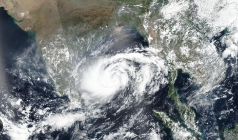
Cyclone Montha has formed over the southeast Bay of Bengal and is steadily intensifying into a severe cyclonic storm. The India Meteorological Department (IMD) has placed several coastal states on high alert, with evacuation plans already underway in vulnerable areas.
Meteorologists predict heavy rainfall, strong winds, and sea surges along the eastern coastline as the storm approaches landfall.
🗓️ Expected Landfall Date and Location
According to IMD forecasts, Cyclone Montha is likely to make landfall on October 28, 2025, between Machilipatnam and Kalingapatnam (near Kakinada, Andhra Pradesh).
Wind speeds at landfall are expected to reach 90–100 km/h, gusting up to 110 km/h.
As the cyclone nears the coast, it is expected to weaken gradually but will continue to bring heavy to very heavy rainfall across several regions.
📍 States Likely to Be Affected
| State | Expected Impact |
|---|---|
| Andhra Pradesh | Coastal districts including Kakinada, Visakhapatnam, and Srikakulam are under red alert for heavy rain and strong winds. Evacuations are underway in low-lying areas. |
| Odisha | Heavy rainfall and strong winds likely in southern districts; yellow alert issued. |
| Tamil Nadu | Northern coastal districts and Chennai may witness moderate rain with gusty winds. |
| West Bengal | Light to moderate rainfall expected in southern parts due to peripheral effects. |
| Telangana & Chhattisgarh | Likely to experience scattered rainfall after landfall as the system weakens inland. |
⚠️ IMD Alerts & Safety Precautions
Coastal residents are advised not to venture near beaches or into the sea until official clearance.
Fishermen have been warned to suspend operations in the Bay of Bengal region.
Local authorities are preparing relief camps and shelters in Andhra Pradesh and Odisha.
Residents should secure loose outdoor objects, stock up on essentials, and keep emergency kits ready.
🌧️ Weather Impact Summary
Heavy Rainfall: Expected across coastal Andhra Pradesh, south Odisha, and northern Tamil Nadu from Oct 27–30.
High Winds: Gusts up to 110 km/h may disrupt power and communication lines.
Sea Conditions: Extremely rough; wave heights expected to increase near landfall areas.
Post-Landfall Effects: Inland rainfall could impact Telangana and Chhattisgarh with moderate showers.
❓ FAQs on Cyclone Montha
1. What is Cyclone Montha?
Cyclone Montha is a tropical storm forming over the southeast Bay of Bengal, categorized as a severe cyclonic storm by the IMD.
2. When will Cyclone Montha make landfall?
It is expected to make landfall on October 28, 2025, between Machilipatnam and Kalingapatnam, near Kakinada in Andhra Pradesh.
3. Which states will be affected the most?
The most affected states are Andhra Pradesh and Odisha, with significant rainfall also likely in Tamil Nadu, West Bengal, and Telangana.
4. How strong will Cyclone Montha be?
At landfall, wind speeds are projected between 90–100 km/h, gusting up to 110 km/h. The storm may weaken into a deep depression after moving inland.
5. What precautions should residents take?
Residents in coastal areas should stay indoors during the cyclone, avoid travel, and follow IMD and local disaster authority instructions. Ensure all essentials (food, batteries, water, and first aid) are stocked.
🌀 Final Word
Cyclone Montha serves as a reminder of the unpredictability of weather patterns over the Bay of Bengal. With early warnings and preventive measures in place, the impact can be minimized.
Citizens are urged to remain vigilant, avoid rumors, and rely only on official IMD updates for accurate information.
Published on : 27th October
Published by : SMITA
www.vizzve.com || www.vizzveservices.com
Follow us on social media: Facebook || Linkedin || Instagram
🛡 Powered by Vizzve Financial
RBI-Registered Loan Partner | 10 Lakh+ Customers | ₹600 Cr+ Disbursed
https://play.google.com/store/apps/details?id=com.vizzve_micro_seva&pcampaignid=web_share