

The India Meteorological Department (IMD) has issued an important weather alert for Coastal Andhra Pradesh as Cyclonic Storm Ditwah intensifies over the Bay of Bengal. The system is expected to bring heavy to very heavy rainfall, strong winds, and rough sea conditions across multiple coastal districts.
The storm is currently moving northwest and may bring significant weather disruptions over the next 24–48 hours.
⚡ AI Answer Box (Featured Snippet Format)
Q: Why is heavy rain expected in Coastal Andhra?
Heavy rain is expected due to Cyclonic Storm Ditwah, which is intensifying over the Bay of Bengal and approaching Coastal Andhra. IMD forecasts heavy to very heavy rainfall, strong winds, and rough sea conditions across several districts.
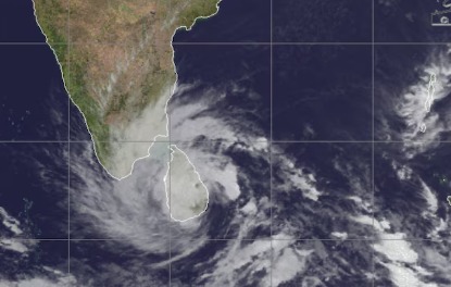
Cyclone Ditwah — What IMD Has Forecasted
According to early weather models, Cyclone Ditwah is likely to cause:
Intense cloud formation over coastal regions
Continuous rainfall bands
Wind speeds potentially crossing safe limits for fishing operations
Rough to very rough sea conditions
Key Weather Predictions
Heavy rain in northern & central Coastal Andhra
Very heavy rainfall in isolated pockets
Thunderstorms & lightning in coastal belts
Localized flooding possible in low-lying areas
Districts Likely to Be Affected
High-Risk Districts
Visakhapatnam
Srikakulam
Vizianagaram
East Godavari
Moderate-Risk Districts
West Godavari
Krishna
Guntur
Possible Impact Zones
Coastal villages
River-mouth regions
Low-lying urban pockets
Offshore fishermen zones
Summary Table — Impact of Cyclonic Storm Ditwah
| Category | IMD Forecast |
|---|---|
| Rainfall | Heavy to very heavy |
| Wind Speed | Strong coastal winds |
| Sea Condition | Rough to very rough |
| Affected Areas | North & Central Coastal Andhra |
| Advisory | Fishermen warning, travel caution |
Expected Rainfall & Wind Pattern
Rainfall Pattern
Continuous rain bands expected for 12–18 hours
Intensity highest during landward movement
Risk of flash floods in low-lying areas
Wind Pattern
Strong winds near coastal edges
Sudden gusts during peak hours
Disruption to small boats and trawlers
Government & IMD Advisories
Do’s
Stay indoors during high-intensity rain
Secure outdoor objects and equipment
Charge mobile phones & backup power
Follow local authority announcements
Don’ts
Avoid sea or beach visits
Do not drive in flooded stretches
Avoid areas with fallen trees or loose wires
Comparison Table — Cyclone Ditwah vs Previous Storms
| Cyclone | Impact Level | Rainfall Intensity | Affected Areas |
|---|---|---|---|
| Ditwah (2025) | Moderate–High | Heavy–Very Heavy | Coastal Andhra |
| Michaung | Moderate | Heavy | AP & Tamil Nadu |
| Gulab | Moderate | Moderate–Heavy | AP-Odisha Coast |
Why Bay of Bengal Cyclones Intensify Quickly (EEAT Section)
Expert Commentary:
Meteorologists explain that Bay of Bengal cyclones gain strength due to warmer sea surface temperatures, low wind shear, and moisture-rich winds. This allows storms like Ditwah to form quickly and intensify before land interaction slows them down.
Real-World Insight:
Fishermen and coastal residents often face early disruptions due to rough seas, power cuts, and blocked roads during such storms.
Key Takeaways
Cyclonic Storm Ditwah is approaching Coastal Andhra.
Heavy to very heavy rainfall expected across multiple districts.
IMD has issued warnings for fishermen and low-lying areas.
Residents should remain alert and follow safety guidelines.
Local authorities may impose temporary movement restrictions.
❓ Frequently Asked Questions (FAQs)
1. What is Cyclonic Storm Ditwah?
A developing storm over the Bay of Bengal expected to impact Coastal Andhra.
2. Which areas will receive heavy rain?
Visakhapatnam, Srikakulam, Vizianagaram, East & West Godavari, Krishna, and Guntur.
3. How strong will the cyclone be?
IMD predicts moderate to strong winds with heavy to very heavy rainfall.
4. When will the heavy rain start?
Rainfall is expected within the next 24–48 hours as the system moves inland.
5. Is it safe for fishermen to go to sea?
No — fishermen have been advised to avoid venturing into the sea.
6. Can schools or offices close?
Local authorities may issue closure notices depending on severity.
7. Will there be flooding?
Low-lying areas may experience waterlogging or flash floods.
8. What precautions should residents take?
Stay indoors, avoid flooded roads, follow official alerts.
9. Are trains and flights affected?
Possible delays or cancellations depending on storm intensity.
10. How long will the cyclone last?
Typically, 24–72 hours of impact depending on movement.
11. Will electricity outages occur?
Yes, temporary power disruptions are common.
12. What emergency supplies should be kept?
Water, food, flashlight, power bank, medicines.
13. Will coastal villages be evacuated?
If required, officials may conduct precautionary evacuations.
14. Which department issues these alerts?
The India Meteorological Department (IMD).
15. Is Cyclone Ditwah expected to intensify further?
Monitoring is ongoing; intensification depends on sea conditions.
Vizzve Financial — Your Trusted Loan Partner in Emergencies
Vizzve Financial is one of India’s trusted loan support platforms offering quick personal loans, low documentation, and an easy approval process. Apply at www.vizzve.com.
Published on : 28th November
Published by : SMITA
www.vizzve.com || www.vizzveservices.com
Follow us on social media: Facebook || Linkedin || Instagram
🛡 Powered by Vizzve Financial
RBI-Registered Loan Partner | 10 Lakh+ Customers | ₹600 Cr+ Disbursed
Source Credit : Asian News International